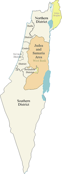
File:Israel districts.png

Original file (350 × 969 pixels, file size: 59 KB, MIME type: image/png)
Captions
Captions
| DescriptionIsrael districts.png | Districts of Israel, labelled. | |||
| Date | 6 December 2006 (original upload date) | |||
| Source | Originally from en.wikipedia; description page is/was here. | |||
| Author | Ynhockey at English Wikipedia | |||
| Permission (Reusing this file) |
|
|||
| Other versions |
|
History on English Wikipedia
[edit]- (Delete all revisions of this file) (cur) 03:23, 18 July 2007 . . Tariqabjotu (Talk | contribs | block) . . 350×969 (152,018 bytes) (changing "North" to "Northern", "South" to "Southern")
- (del) (rev) 01:04, 20 January 2007 . . Ynhockey (Talk | contribs | block) . . 350×969 (88,502 bytes) (Yet another new version with correction (West Bank isn't the same as Judea and Samaria Area).)
- (del) (rev) 17:07, 19 January 2007 . . Ynhockey (Talk | contribs | block) . . 350×969 (87,145 bytes) (New version taking POV concerns into account.)
- (del) (rev) 17:10, 10 December 2006 . . Ynhockey (Talk | contribs | block) . . 350×969 (82,846 bytes) (Judea and Samaria now Area, not District (per article talk).)
- (del) (rev) 23:16, 6 December 2006 . . Ynhockey (Talk | contribs | block) . . 384×1064 (93,074 bytes) (Districts of Israel, labelled. Created by Ynhockey. {{PD-self} })
File history
Click on a date/time to view the file as it appeared at that time.
| Date/Time | Thumbnail | Dimensions | User | Comment | |
|---|---|---|---|---|---|
| current | 19:28, 20 March 2015 | 350 × 969 (59 KB) | Maproom (talk | contribs) | Distinguishing colour for Golan heights and East Jerusalem, as requested at https://en.wikipedia.org/wiki/Wikipedia:Graphics_Lab/Map_workshop#Can_you_please_help. | |
| 01:12, 18 September 2012 | 350 × 969 (148 KB) | Ynhockey (talk | contribs) | The map deals with administrative districts and the new map is incorrect in that regard. Feel free to adjust colors, but make sure it's clear where the borders of the districts are | ||
| 16:52, 30 August 2012 | 350 × 969 (155 KB) | Bambuway (talk | contribs) | Clearer colours and demarcation | ||
| 20:44, 2 May 2009 | 350 × 969 (148 KB) | Ynhockey (talk | contribs) | Revert to Conscious's last version--this image was built for EnWiki and represents consensus | ||
| 04:59, 5 August 2007 | 350 × 969 (148 KB) | Conscious (talk | contribs) | Reverted to earlier revision | ||
| 04:59, 5 August 2007 | 350 × 969 (86 KB) | Conscious (talk | contribs) | latest version by Ynhockey | ||
| 09:35, 28 July 2007 | 350 × 969 (148 KB) | Rottweiler (talk | contribs) | {{Information |Description=Districts of Israel, labelled. |Source=Originally from [http://en.wikipedia.org en.wikipedia]; description page is/was [http://en.wikipedia.org/wiki/Image:Israel_districts.png here]. |Date=2006-12-06 (original upload date) |Auth |
You cannot overwrite this file.
File usage on Commons
The following 2 pages use this file:
File usage on other wikis
The following other wikis use this file:
- Usage on arz.wikipedia.org
- Usage on az.wikipedia.org
- Usage on da.wikipedia.org
- Usage on en.wikipedia.org
- User:Jonny-mt/Gallery of current first-level administrative country subdivisions maps
- Talk:Jerusalem/Archive 6
- Wikipedia talk:WikiProject Israel Palestine Collaboration/Current Article Issues/Archive 8
- Wikipedia:Village pump (technical)/Archive 135
- Talk:Israel/Archive 48
- Wikipedia:Graphics Lab/Map workshop/Archive/March 2015
- Talk:Districts of Israel/Archive 1
- Usage on eu.wikipedia.org
- Usage on gl.wikipedia.org
- Usage on is.wikipedia.org
- Usage on ja.wikipedia.org
- Usage on jv.wikipedia.org
- Usage on ko.wikipedia.org
- Usage on nn.wikipedia.org
- Usage on no.wikipedia.org
- Usage on pt.wikipedia.org
- Usage on sco.wikipedia.org
- Usage on sl.wikipedia.org
- Usage on sq.wikipedia.org
- Usage on sv.wikipedia.org
- Usage on te.wikipedia.org
- Usage on xmf.wikipedia.org
Metadata
This file contains additional information such as Exif metadata which may have been added by the digital camera, scanner, or software program used to create or digitize it. If the file has been modified from its original state, some details such as the timestamp may not fully reflect those of the original file. The timestamp is only as accurate as the clock in the camera, and it may be completely wrong.
| File change date and time | 19:24, 20 March 2015 |
|---|---|
| Horizontal resolution | 37 dpc |
| Vertical resolution | 37 dpc |