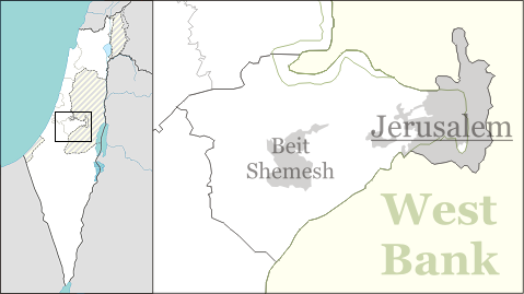
File:Israel outline jerusalem.png
From Wikimedia Commons, the free media repository
Jump to navigation
Jump to search
Israel_outline_jerusalem.png (479 × 269 pixels, file size: 49 KB, MIME type: image/png)
File information
Structured data
Captions
Captions
Jerusalem District of Israel
Jerusalém, Distrito de Israel

|
This map image could be re-created using vector graphics as an SVG file. This has several advantages; see Commons:Media for cleanup for more information. If an SVG form of this image is available, please upload it and afterwards replace this template with
{{vector version available|new image name}}.
It is recommended to name the SVG file “Israel outline jerusalem.svg”—then the template Vector version available (or Vva) does not need the new image name parameter. |
Summary
[edit]| DescriptionIsrael outline jerusalem.png |
English: Labelled map for pushpin maps of the Jerusalem District of Israel. |
| Date | |
| Source | Own work |
| Author | Ynhockey |
Licensing
[edit]I, the copyright holder of this work, hereby publish it under the following licenses:
This file is licensed under the Creative Commons Attribution-Share Alike 3.0 Unported license.
- You are free:
- to share – to copy, distribute and transmit the work
- to remix – to adapt the work
- Under the following conditions:
- attribution – You must give appropriate credit, provide a link to the license, and indicate if changes were made. You may do so in any reasonable manner, but not in any way that suggests the licensor endorses you or your use.
- share alike – If you remix, transform, or build upon the material, you must distribute your contributions under the same or compatible license as the original.

|
Permission is granted to copy, distribute and/or modify this document under the terms of the GNU Free Documentation License, Version 1.2 or any later version published by the Free Software Foundation; with no Invariant Sections, no Front-Cover Texts, and no Back-Cover Texts. A copy of the license is included in the section entitled GNU Free Documentation License.http://www.gnu.org/copyleft/fdl.htmlGFDLGNU Free Documentation Licensetruetrue |
You may select the license of your choice.
File history
Click on a date/time to view the file as it appeared at that time.
| Date/Time | Thumbnail | Dimensions | User | Comment | |
|---|---|---|---|---|---|
| current | 17:32, 1 September 2016 |  | 479 × 269 (49 KB) | Number 57 (talk | contribs) | Updated Israel map |
| 00:19, 6 December 2008 |  | 479 × 269 (53 KB) | Ynhockey (talk | contribs) | {{Information |Description={{en|1=Labelled map for pushpin maps of the Jerusalem District of Israel.}} |Source=Own work by uploader |Author=Ynhockey |Date=2008-12-06 |Permission= |other_versions= }} <!--{{ImageUpload|full}}--> [[Categor |
You cannot overwrite this file.
File usage on Commons
The following 2 pages use this file:
File usage on other wikis
The following other wikis use this file:
- Usage on arz.wikipedia.org
- Usage on bn.wikipedia.org
- Usage on ceb.wikipedia.org
- Usage on ckb.wikipedia.org
- Usage on el.wikipedia.org
- Usage on en.wikipedia.org
- Neve Shalom
- Beit Shemesh
- Kiryat Menachem bus bombing
- Shmuel HaNavi bus bombing
- Ramathaim-Zophim
- Mevaseret Zion
- Aderet, Israel
- Sbarro restaurant suicide bombing
- Kiryat Anavim
- Ramat Rachel
- Abu Ghosh
- Patt Junction bus bombing
- Har Gilo
- Tzora
- Kiryat Ye'arim
- Zanoah
- Shoresh
- Bar Giora
- Gaza Street bus bombing
- Sdot Micha Airbase
- Sdot Micha
- Tel Aviv–Jerusalem bus 405 suicide attack
- Jaffa Road bus bombings
- Aminadav
- Nes Harim
- Aviezer
- Even Sapir
- Yad La-Shiryon
- Naham
- Giv'at Ye'arim
- Eitanim
- Ramat Eshkol bus bombing
- Neve Ilan
- Khirbet Qeiyafa
- Nataf
- Beit Meir
- Ma'ale HaHamisha
- Eshtaol
- Yad HaShmona
- 2008 Jerusalem yeshiva attack
- Tzur Hadassah
View more global usage of this file.
Metadata
This file contains additional information such as Exif metadata which may have been added by the digital camera, scanner, or software program used to create or digitize it. If the file has been modified from its original state, some details such as the timestamp may not fully reflect those of the original file. The timestamp is only as accurate as the clock in the camera, and it may be completely wrong.
| Horizontal resolution | 37.8 dpc |
|---|---|
| Vertical resolution | 37.8 dpc |
