File:Operation-Pleshet-map1.png
From Wikimedia Commons, the free media repository
Jump to navigation
Jump to search

Size of this preview: 529 × 600 pixels. Other resolutions: 212 × 240 pixels | 423 × 480 pixels | 900 × 1,020 pixels.
Original file (900 × 1,020 pixels, file size: 152 KB, MIME type: image/png)
File information
Structured data
Captions
Captions
Add a one-line explanation of what this file represents
Summary
[edit]| DescriptionOperation-Pleshet-map1.png |
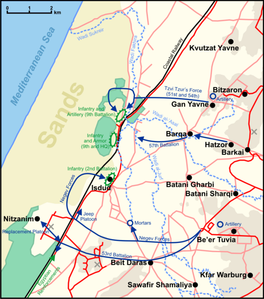
English: Map of the Israeli attacks on Egyptian positions during Operation Pleshet.
Note: The map is as geographically accurate as possible, although since some of the streams were since diverted, and most of the maps from the period do not exactly match, it is difficult to say for sure, and small errors likely exist. |
| Date | |
| Source | Own work |
| Author | Ynhockey |
| Other versions | File:Operation-Pleshet-map heb.png (Hebrew), File:Operation-Pleshet-map rus.png (Russian) |
Legend
[edit]There are four background colors on the map: Green stands for plantations and groves, the brownish color on the left is sand dunes, and the rest is regular ground (darker indicates an elevation of above 50 m)
Lines:
- Red: roads
- Pink: very minor roads or unpaved paths
- Black: railways
- Baby blue: wadis
Other:
- Black circles: villages
- Dark blue lines and arrows: Israeli movement
- Green lines and arrows: Egyptian movement
- Green ellipse: Egyptian position
- Blue cicle: Israeli mortar and field artillery
- Grey X: Former British military base
Sources used in making the map
[edit]- Carta's Atlas of Israel (1978), vol. 2, p. 32 (map 46)
- Battle Sites in the Land of Israel (2003), p. 24
- Ayalon, Avraham (1963), Givati Brigade Against the Egyptian Invader, pp. 120, 131
- Palestine Exploration Fund maps (such as here)
- http://www.amudanan.co.il archive copy at the Wayback Machine
Licensing
[edit]I, the copyright holder of this work, hereby publish it under the following licenses:
This file is licensed under the Creative Commons Attribution-Share Alike 3.0 Unported license.
- You are free:
- to share – to copy, distribute and transmit the work
- to remix – to adapt the work
- Under the following conditions:
- attribution – You must give appropriate credit, provide a link to the license, and indicate if changes were made. You may do so in any reasonable manner, but not in any way that suggests the licensor endorses you or your use.
- share alike – If you remix, transform, or build upon the material, you must distribute your contributions under the same or compatible license as the original.

|
Permission is granted to copy, distribute and/or modify this document under the terms of the GNU Free Documentation License, Version 1.2 or any later version published by the Free Software Foundation; with no Invariant Sections, no Front-Cover Texts, and no Back-Cover Texts. A copy of the license is included in the section entitled GNU Free Documentation License.http://www.gnu.org/copyleft/fdl.htmlGFDLGNU Free Documentation Licensetruetrue |
You may select the license of your choice.
File history
Click on a date/time to view the file as it appeared at that time.
| Date/Time | Thumbnail | Dimensions | User | Comment | |
|---|---|---|---|---|---|
| current | 07:56, 3 August 2009 |  | 900 × 1,020 (152 KB) | Ynhockey (talk | contribs) | Added more info on Egyptian positions |
| 02:09, 20 June 2009 |  | 897 × 1,019 (149 KB) | Ynhockey (talk | contribs) | Added some groves important to the battle, also slightly modified Tzur force's movement | |
| 22:26, 17 June 2009 |  | 897 × 1,019 (149 KB) | Ynhockey (talk | contribs) | Corrected some wadi-related issues | |
| 21:47, 17 June 2009 |  | 900 × 1,020 (149 KB) | Ynhockey (talk | contribs) | More accurate Irgun battle movements, according to the text from Ayalon's book. | |
| 19:52, 16 June 2009 |  | 900 × 1,020 (149 KB) | Ynhockey (talk | contribs) | {{Information |Description={{en|1=Map of the Israeli attacks on Egyptian positions during Operation Pleshet. Note: The map is as geographically accurate as possible, although since some of the streams were since diverted, and most of the maps from the pe |
You cannot overwrite this file.
File usage on Commons
The following page uses this file:
File usage on other wikis
The following other wikis use this file:
- Usage on cs.wikipedia.org
- Usage on de.wikipedia.org
- Usage on en.wikipedia.org
- Usage on es.wikipedia.org
- Usage on pl.wikipedia.org
- Usage on sr.wikipedia.org